

NOTAM Briefings
A briefing collects every airspace and NOTAM around an airport, a point or along a route into one list, a pre-flight information bulletin (PIB). Open it with the clipboard button at the top of the map, or press B.
Anyone can create, edit and share briefings. Live adds activation status to the briefing and lets you print it or save it as a PDF.
Choose the area
The editor is called NOTAM PIB Editor. Add one or more waypoints:
- type an ICAO code or airport name, for example
EHAM; - tap Select on Map to Add, then tap the map;
- tap Current position to add where you are.
With one waypoint, the briefing covers a circle. Set its Radius (10 NM by default). With two or more, it covers a corridor along the route. Set the Corridor Width, the width on each side of the route (3 NM by default). Tap the unit to switch between NM and km. A route can have up to 30 waypoints.
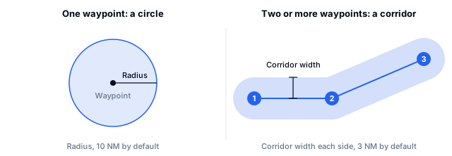
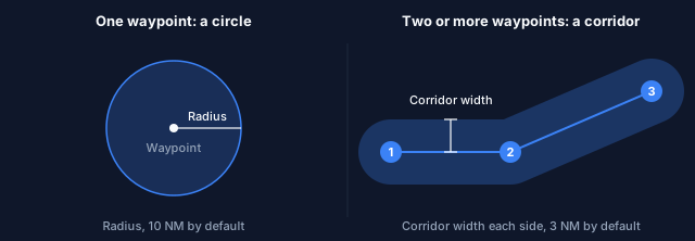
The route and corridor appear on the map while you edit, with numbered waypoints.
Edit a route
- Reorder: drag a waypoint up or down in the list.
- Insert: use the
+between two waypoints, or drag a route leg on the map. - Remove: right-click a waypoint on the map, or long-press it on a phone and tap Delete.
- Undo and redo: use the arrow buttons,
Ctrl+ZandCtrl+Y, or your browser's back and forward buttons.
Tap Generate Briefing (or Update Briefing when you changed an existing one) to build it. To leave the editor without your changes, use the close button and choose Discard.
More background: Airport radius briefing and Route briefing.
Read the briefing
The briefing groups what it found:
- Graphical NOTAMs
- Airport NOTAMs
- Point NOTAMs
- Dynamic Airspaces
- Other Airspaces
- Not Active Airspaces
The top of the briefing shows whether it uses live data, how many items it has, and a button to refresh it.
Select an item to fly the map to it and highlight it.
Your map filters also apply to the briefing. The Map Filters, also applied to briefing card shows the time window and how many exclusions are active. Open Exclusion details to see them, or tap Edit to change the filters.
Save, share and clear
The top of the briefing shows the area, the time it covers, the kind of area with its item count, and the actions:
- Edit opens the editor again.
- Print / PDF prints the briefing or saves it as a PDF (Live).
- Save (bookmark) keeps it in your list of saved briefings. You need to sign in. A filled bookmark means it is saved; tap it again to remove it from the list.
- Share opens your device's share menu, or copies a link. The link includes your time window. Whoever opens it sees current data with their own plan.
- More (⋯) holds New briefing, which opens an empty editor and keeps the current briefing until you generate the new one, Refresh data, and Clear briefing, which takes the briefing off the map. Saved briefings stay, and Undo brings it back.
- The close button hides the panel. The briefing stays on the map, and the briefing button brings it back.
In the editor, Clear route removes all waypoints but keeps your current briefing.
When you are signed in, the briefing panel lists your saved and recent briefings. The app also remembers your last briefing on this device and shows it again when you come back.
Print and PDF (Live)
The PDF shows when it was generated, the period it is valid for, the data source, who prepared it and every exclusion that was active, so the printout explains itself. It also links back to the briefing online.


The file name holds the area and the UTC time, for example NOTAM-Briefing-EGLL-50nm-2026-04-11-1430UTC.
A share link always shows current data. For a record of what you saw at a point in time, save a PDF.